Trimble X7 3D Scanning System
The Trimble X7 3D Scanning System is a high-speed 3D scanning system with advanced technologies and an array of features which makes it extremely effective at scanning environments and creating 3D rendered models from the data it collects. The models can be used for analysis and a whole range of surveying and geospatial applications.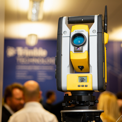
The X7 comes with a range of high-tech innovations as standard, including the automatic calibration, Trimble registration assist, Georeferencing, and in-built software that can be paired with the Trimble app. The Trimble Perspective mobile app provides the core functionality of the field software for controlling the scanner. You can create new projects, set scan and imaging parameters, and view the scans and images in the field.
When you will use this equipment: You will use this equipment when studying surveying, analysis, construction management modules in courses related to Building & Surveying.
Where this can be found: The Trimble Technology Lab in Merchiston campus
Who to contact: Please contact Dr Suha Jaradat at S.Jaradat@napier.ac.uk for any enquiries
Trimble Connect AR
Edinburgh Napier University has partnered with Trimble Technology to deliver a suite of state-of-the-art equipment that will be used by teachers and students to enhance learning in Building & Surveying courses.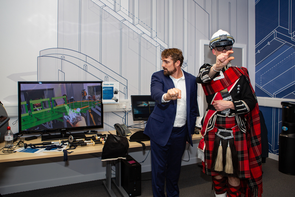
The Trimble Connect Augmented Reality (AR) is a wearable headset that allows the user to visualise and analyse their surrounding with additional components. This technology allows the user to go onto a building site and visualise where all the pipework and structures will go in real time from a first-person perspective, and then move around the area to understand the configuration and make changes.
Trimble Connect AR enables you to improve your Quality Control workflows by viewing your digital models at a 1:1 scale onsite and in context. Allowing the user to detect errors, observe omissions, and visually collaborate to resolve them.
When you will use this equipment: You will use this equipment when studying surveying, analysis, construction management modules in courses related to Building & Surveying.
Where this can be found: The Trimble Technology Lab in Merchiston campus
Who to contact: Please contact Dr Suha Jaradat at S.Jaradat@napier.ac.uk for any enquiries
Other Equipment
Trimble ZX5 Multirotor Unmanned Aircraft System
The Trimble Multirotor Unmanned Aircraft Vehicle is an aerial imaging tool that captures and processes geo-referenced photo and video data for mapping and inspecting areas of land.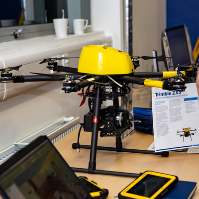
This drone UAV is able to follow a pre-programmed path where take off, flight, and landing require minimal human intervention. The ZX5 holds a camera that captures aerial images of a defined area from a specified height. Alternatively, the rover can be operated manually, allowing the operator to have full control over flight path and camera angle. Typical applications of this piece of equipment include Orthophoto creation, Digital Elevation Model (DEM) or Digital Surface Model (DSM), and Photogrammetry. These can be used in a whole range of ways like topographical surveying and infrastructure mapping, while the stills captured can be used for architectural and building inspection and more.
When you will use this equipment: You will use this equipment when studying surveying, analysis, construction management modules in courses related to Building & Surveying.
Where this can be found: The Trimble Technology Lab in Merchiston campus
Who to contact: Please contact Dr Suha Jaradat at S.Jaradat@napier.ac.uk for any enquiries